mbCDQ | 18 Apr 2024
The Cap de Creus Natural Park stretches from Roses in the south to Port de la Selva in the north and Cadaques in the East. It also encompasses a large area of the mediterranean sea bordering the shoreline.
The park has an area of 13,483 hectares, of which 10,780 are land and 3,063 are sea.
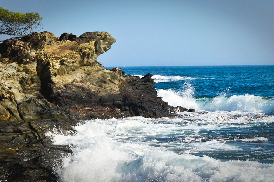
It is famous for its barren, windswept and rocky landscape. The park takes its name from the cape at Cap de Creus, the most easterly point in the whole of peninsula Spain. The cape, and the barren, rocky peninsula to which it belongs, are the most visited parts of the park. Those familiar with the works of Salvador Dali may recognise Cap de Creus from his paintings, as the artist often used the rock and seascapes as backdrops for his surrealist creations.
Cadaques is the closest town and most visitors will start their trips to Cap de Creus from here. By far the most popular trip is a visit to the lighthouse at the edge of the cape.

In 1985 the Cap de Creus peninsula was designated a Natural Park by the Parliament of Catalonia with the aim of preserving its landscapes and ecosystems, and protecting the area from the worst excesses of the 'brick fever' that had destroyed many other natural landscapes in the Costa Brava. Its official name in Catalan is Parc Natural de Cap de Creus.
Geologically, Cap de Creus is an extension of the great Pyrenees mountain range, although here the mountains do not exceed 650 metres and descend quickly towards the sea. The park is a dry and rocky area, a land surrounded by water but where rains are not frequent.
Being a peninsula, Cap de Creus is at the mercy of the winds, the most notable being the Tramuntana (which blows from the northwest).
The Grandes rutas (Great Routes) are long-distance walking trails that cross some of the most beautiful areas of Spain. The Spanish network links with those of France and Portugal to form a huge trans-European network. The Cap de Creus natural park is the intersection point of two important GRs: GR11 and GR92.
The GR 11, also known as the Senda Pirenaica, crosses the entire Spanish Pyrenees from Cape Higuer in the Basque Country to Cap de Creus.
The GR92 is the Mediterranean Trail. It runs alongside the Mediterranean Sea from Andalusia in the south to Port Bou, on the border with France. In Port Bou it joins the E10 trail that comes down from the Baltic Sea. One of its most popular sections is Cadaqués-Roses (or Roses-Cadaqués), a route of a little more than 20km that allows you to enjoy one of the most beautiful (and most unspoilt) areas of the entire Spanish Mediterranean coast.

Although the entire Cap de Creus peninsula stands out for being rugged, dry and windswept, the Pareja de Tudela (Paratge de Tudela in Catalan) is where these three characteristics are at their most extreme.
Being oriented to the north, the attack of the Tramuntana here is brutal. The wind is so strong in Tudela that it sculpts the rock itself, leaving surreal shapes and removing most of the soil, forcing the flora to choose between adapting or dying. It is here, in a garden of natural sculptures, that Salvador Dali found the inspiration for some of his most famous paintings.
Today the Tudela area enjoys a special level of protection. Neither cars nor bicycles are allowed to enter. Visitors are allowed to walk as long as they do not deviate from the marked path. There is a car park at the entrance.

Without a doubt the most visited place in the park, despite recent traffic restrictions (see below).
The lighthouse marks the easternmost point not only of the cape but of the entire Iberian Peninsula.
The views from the lighthouse and its surroundings are very beautiful. Towards the south you can see the town of Cadaqués and the almost 600m of the Pení 'mountain' with the two radars of the military base on the top. If the skies are clear (which is usually the case) you can guess the southern point of the Gulf of Roses and the Medes Islands.
Towards the north you can clearly see the entire Alt Emporda coast almost to the border with France. The Pyrenees and the pre-Pyrenees mountains form an impotent double backdrop.
In the lighthouse there is a small museum (open in summer) with information about the flora and fauna of the region as well as the peculiar geology of Cap de Creus.
From the Cap de Creus lighthouse, a small low dirt path leads to the Cova del Infern, a beautiful cave, with a natural pool, that the Mediterranean Sea has created, taking advantage of a gap between two rock strata.
There are currently two places next to the lighthouse that offer food and drink. One is a small café with a terrace serving tea, coffee, soft drinks and pastries. The other is the legendary Cap de Creus restaurant, established by a British 'hippy' more than 30 years ago in an old Civil Guard building.
It's possible to follow the coastal path (Camino de la Ronda) all the way from the centre of Cadaques to the lighthouse at Cap de Creus. However, the more direct route, and the one favoured by the majority of walkers is to walk from Cadaques to Port LLigat by road and then continue on 5 minutes to pick up the coastal path (GR92 - One of the Spanish ‘Grandes Rutas' long distance pathes) above the beaches of S'Alqueria. From this point the walk will last between 1 ¼ and 1 ¾ hours depending on your speed. While you never go beyond 100 metres above sea level, the route is made up of constant ups and downs which can be quite tiring, particularly for those used to sitting at a desk all day. In some places, particularly on the steeper sections, the trail is not in the best of conditions (This is post-crisis Spain, so money is tight!) and it's advisable to wear proper footwear, either dedicated walking boots or a durable pair of sports shoes. Remember to take water, it can get pretty hot and dusty in summer.
Want to now where the only sand beach in the park is located. Fill in a form and we'll send you details by email.
Important!: During summer months - and weekends in Spring/Autumn - access to the cape is restricted. Only cars registered in Cadaques are allowed to take the last 5km of road from the cillage to the lighthouse at Cap de Creus.
To get to Cap de Creus by car, take the Carretera de Port LLigat from the roundabout at the entrance to Cadaqués and then follow the signs. The road takes you through the top end of the village and then winds 8km through the natural park before terminating at the lighthouse of Cap de Creus, the most easterly point not just of the park but of the whole of Spain.
Be aware that the route is narrow and badly maintained, with many potholes. Successive layers of tarmac have been laid one over the other, so the edges of the road can be some height above the bordering verge. Pay attention when giving more space to oncoming vehicles or pulling over to take photos.
There isn't a huge amount of parking space once you get to the cape.
In the peak summer months of July and August be prepared for a fairly frustrating wait, particularly if you are arriving around lunchtime. Those arriving by motorbike should have more luck, but watch out for tired, hot drivers making stupid manoeuvres.
While it's only 8km from Cadaques to the lighthouse at Cap de Creus it is almost never flat and some of the uphill sections can be pretty hard work. On a hot summer's day the trip can be pretty tiring. That said, if you're reasonably fit it shouldn't take more than 35 minutes and you won't have the problem of where to park once you arrive. If you've hired or borrowed a bike make sure it's low-geared.
An electric bike is a great alternative to a normal bicycle. You'll still have to pedal, but the hills will be some much easier when the electric motor kicks in.
The road can get quite busy in summer, and while the cars are travelling fairly slowly, there isn't much room on the narrow road, so care should be taken.

Everything you need to know about Cadaques from the best beaches in the area, to walking routes in the Cap de Creus Natural Park and advice for visiting the Casa/Museu Salvador Dali.

Our guide to the many restaurants and bars of Cadaques, Spain. From former hippy hangouts to live music venues and sophisticated waterside dining, there are more than 100 bars and restaurants to choose from.


Free materials for teachers of English as a foreign language.

Start to learn Spanish from scratch with this easy-to-follow Basic Spanish course.

Prepare for your trip to Spain by listening to these simple conversations.